Hiking the Sorte Naese Trail in Lodbjerg
Jutland's west coast is home to the stunning Sorte Naese trail - a perfect spot for nature lovers and hikers!
The Sorte Næse was our favorite hike in Denmark's Thy National Park - here are all the essentials, including a complete trail description.
With Thy National Park just around the corner, we realized we hadn't planned which hike to tackle. Thankfully, during the 15-minute Thyboron-Agger Ferry ride across Limfjord to Northern Jutlandic Island, we had time to sort it out. We knew right away that Lodbjerg would be our first destination in Thy National Park, with its historic lighthouse, scenic cliffs, and a few great walking paths.
After doing a few short walks on Romo Island, we were itching for a proper hike - you know, the kind that's on the park map with signs and a difficulty rating. As we were looking through the park's official brochure, the Sorte Naese trail really caught our eye, but we weren't sure how its 2-hour circular route would fit into our plans.
We decided just to walk as far as we felt like, and if we were into the trail, we'd finish it. A few minutes in, we realized how gorgeous the scenery around Lodbjerg was, so we ended up doing the whole loop - and here's the story of our little adventure.

We think the Lodbjerg area offers some of the prettiest coastal scenery in the whole park.
Sorte Naese Trail Difficulty
The 6.2-kilometer Sorte Naese trail is marked as difficult, but honestly, it didn't feel that hard to us. In fact, we'd say it was more like an easy to moderately challenging hike.
Being on Jutland's coast, there was basically no elevation change - just a flat trail with a 30-meter gain, mainly from heading down to the beach and back. Plus, the terrain wasn't as tough as we expected based on the short description we'd read.
To be fair, we had perfect hiking conditions - good weather, hardly any wind, no recent rain, and the sea was out. Any of these factors could've easily made the trail much tougher. The first stretch of the trail through the heathland toward the beach can get pretty wet and muddy if the weather's bad or it's rained lately.
Another thing to keep in mind is the tides. From what we found, Sorte Naese can be hiked during high tide, but parts of the beach might be underwater, so you'll probably end up with wet feet. Since we did the hike when the beach was completely dry, we're not sure how much of an issue this could be.

Low tide made the beach walk at Lodbjerg so much easier.
Also, keep in mind that a large portion of the trail is sandy, which makes the walking a bit more physically challenging.
Finally, remember that the trail is pretty exposed, so if the weather takes a windy or rainy turn, walking along the beach could be much tougher mentally. It really brought back memories of the South Coast Track we did a few years back in similar weather and how tiring that experience was.
Hiking the Sorte Naese Trail
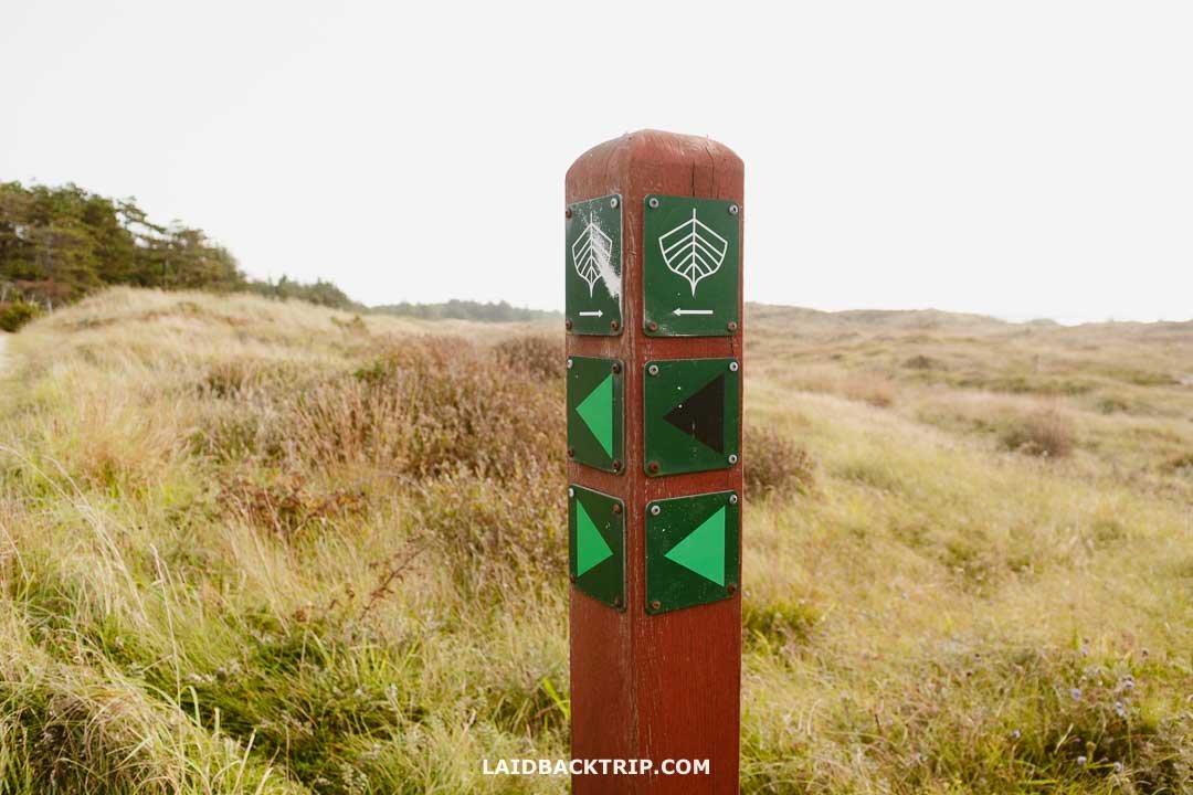
As we hinted earlier, we didn't have a lot of extra time, so we grabbed the essentials, laced up our hiking shoes, and hit the Sorte Naese trail without delay. Passing by the Lodbjerg Lighthouse, we picked up the Sorte Naese trail at the first waymarker we saw: a wooden brown post with a black arrow.

You'll find the starting point for Sorte Naese at Lodbjerg Lighthouse.
As we started on Sorte Naese, the trail led us through Lodbjerg Klitplantage, a forest that even houses the parking lot and, interestingly enough, the lighthouse. It's a big conifer forest created to stop the sandy coastline from eroding - a concept we've come across in several other Jutland locations, too.

Just a small section of the trail winds through Lodbjerg Klitplantage.
Just a few minutes into the hike, we reached a vast dune heath, where the views really opened up. The trail across the heathland was easy to follow, and the fantastic weather sealed the deal - we were going to finish the entire hike.

The dune heath all around us was pretty cool to see.
As we continued on, the grassy dirt path gave way to a sandy trail, making things trickier - our feet started sinking, and sand grains constantly found their way into our shoes, which was quite irritating. Getting closer to the beach, the trail basically disappeared into the tussock grass. Luckily, it wasn't too dramatic, and it was only for a short section, so we didn't lose our way.

Lucie working her way across a patch of tussocks.
As we arrived at the cliff edge, we spotted a rope fixed there to help people descend to the beach. The cliff with the rope looked very steep, almost like a vertical drop. We glanced around and noticed a well-trodden sand path just a few meters away from the rope - it was immediately clear that this was the way to go. We're not sure how much the cliff shifts over time, but we were definitely relieved we didn't need to tackle it.

We found a sandy path close by to get around the rope part.
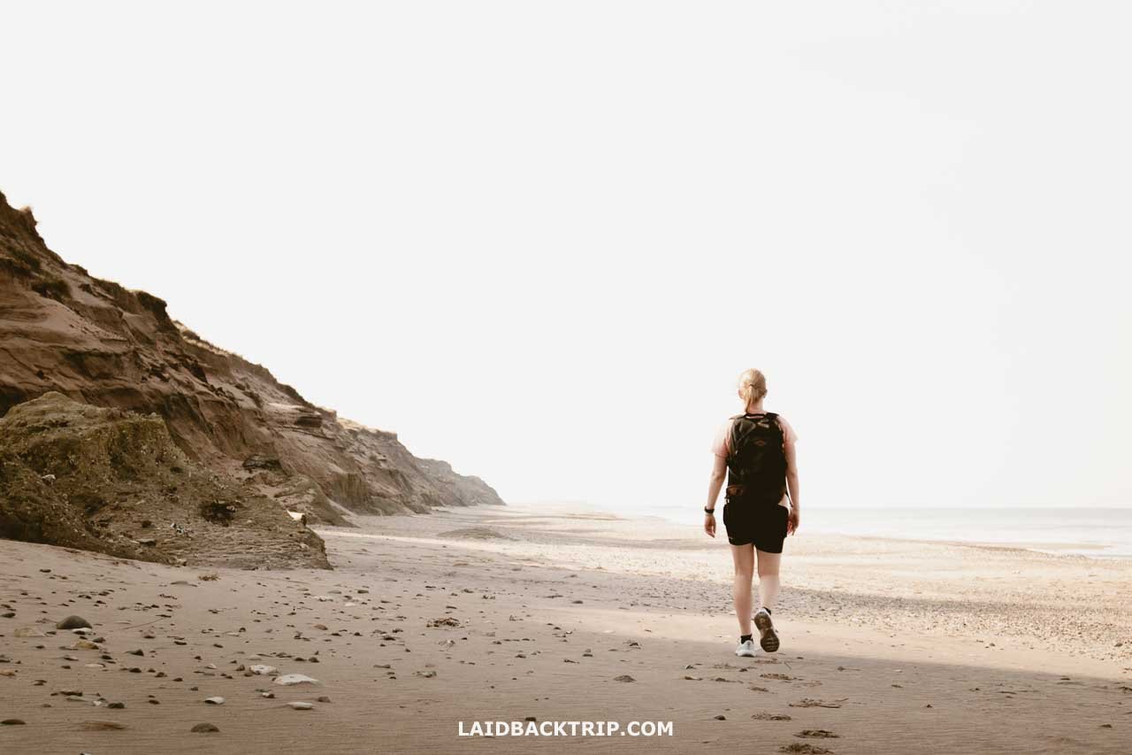
With a quick descent behind us, we headed left and started the 2.4-kilometer beach walk. The beach was completely deserted and seemed to go on forever. It dawned on us that, aside from a few tourists picnicking near the lighthouse, we hadn't seen anyone in the last twenty minutes.
For the next 40 minutes or so, nothing changed - it was just us and the trail. It was such a nice treat to have this part all to ourselves, though we did notice some footprints in the sand and a few tracks, likely from ATV bikes.
Lodbjerg Strand stretches out over a few kilometers.
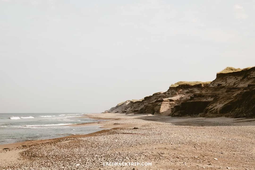
The following section of the Sorte Naese trail looked just as we'd imagined - flat and sandy, with cliffs rising to our left and a calm sea stretching out on the right. It was so peaceful we felt like we could walk for eternity. Walking on the beach was a bit tougher, but only in a few spots with that dry, soft sand where we had to put in more effort. Most of the time, we found firm patches that made it easier to walk.
While these cliffs are relatively low (just 10-20 meters) and not as striking as Mons Klint or Stevns Cliffs we saw later, they were still really cool. The highlight here was definitely the peat soil and dark moraine clay deposits from the last Ice Age. Their dark color is what earned the trail its name, Sorte Naese, or Black Nose.

Lodbjerg's cliffs are layered with dark moraine clay deposits.
The trail wasn't marked here, which wasn't a big deal since there was only one clear direction to go. The only issue was not knowing what the next entry/exit point would look like. By the time we reached the 2.4-kilometer mark, I had been glancing at my phone, but it turned out to be unnecessary - a wooden waymarker stood at the cliff's edge. No rope was needed since the climb back up was surprisingly simple.

We could easily spot the wooden waymarker from the beach.
There's really no chance of getting lost here. Even without spotting the waymarker, the beach stops after a couple of hundred meters, and you'll notice it because you'll run into one of those breakwaters (groynes) that help protect the coast heading south.
If you accidentally end up here, you can always backtrack to the beach and look for the waymarker again. That said, since the Flade Sø Trail (green marker) also starts from the breakwaters and connects Lodbjerg with Agger Tange to the south, it's simpler just to join that dirt path and head toward the lighthouse instead.

Jutland is absolutely stunning.
In any case, the Flade Sø trail merges with the black trail, so you'll end up on it no matter what. After leaving the beach, we noticed we'd missed the main path by a bit and had to join it through a slightly less official route. We passed by a kayak and paddleboard trailer before reaching the next junction, where we turned left toward the lighthouse.
Here, Sorte Naese and Flade So came together into one trail, taking us back to the lighthouse.
This was where we finally crossed paths with another tourist - a cyclist heading to Lodbjerg from Agger Tange, who sped by in no time. The 2.5-kilometer stretch back to the lighthouse was mostly a well-maintained dirt path. Since it's also a bike route, it was in great condition but lacked a sense of adventure.
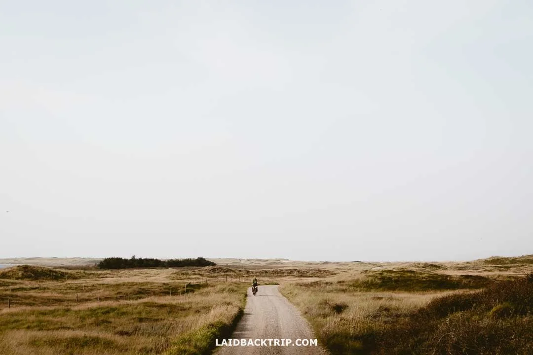
As soon as we hit the cycling route, we made way faster progress back to the car.
The trail took us through another stretch of heathland, but this time, there were bits of forest on our right-hand side. Less than 30 minutes later, we were back at the parking lot, shaking out as much sand as we could from our shoes, then jumping into the car to head to our next stop.

We could finally see Lodbjerg Lighthouse in front of us once more.
It took us around 90 minutes to complete the Sorte Naese Loop. That said, making longer stops or dealing with less cooperative weather could stretch it to two hours. If you've got some extra time, there are two more places nearby you could explore.
Travel Insurance
We never leave home without travel insurance that was designed to cover our expenses if something goes wrong during the trip.
Travel insurance protects against theft, flight delays, injury, illness, cancellations, and much more.
World Nomads provides travel insurance for travelers to cover their trip essentials, including sports and adventure activities.
SafetyWing is affordable travel insurance for backpackers, long-term travelers, and digital nomads.
Travel smarter and safer!
Lodbjerg Lighthouse
Since we were focused on hiking and had already caught the sunrise at Bovbjerg Lighthouse (with Rubjerg Knude lined up for sunset), we skipped going inside Lodbjerg. That said, if you're into coastal lighthouses, it's definitely worth checking out.
Inside, there are exhibitions that dive into the history of the lighthouse, from its 1883 origins to its role in maritime navigation. It's especially interesting if you haven't been inside a lighthouse before. The coolest thing about the 35-meter-high Lodbjerg Lighthouse? You can climb up and take in some amazing views of Jutland's flat and unique landscape.

Lodbjerg Lighthouse is open for everyone to visit.
Since our itinerary was packed and already lighthouse-heavy, we skipped this one and headed north to Hanstholm Fortress. It's packed with WW2 history and seemed like a super exciting stop.
Entry to Lodbjerg Lighthouse costs 30 DKK, and it's open from 7 AM to 9 PM. There's a charming little café managed by volunteers and a picnic area that's ideal for families with kids.
A Quick Stop at Lodbjerg Church
On your way to or from Lodbjerg, you can stop by Lodbjerg Kirke, just 3 kilometers from the lighthouse. It's one of Denmark's tiniest churches, making it a cute stop if you've got some extra time. It's definitely no Roskilde Cathedral, but it's worth a visit if you're interested in less-known places. We skipped it since we were running behind and ended up spending more time around the lighthouse than planned.
Practical Information
Lodbjerg and Sorte Naese Trail is super easy to access. You can cover the whole Lodbjerg area in about 2 to 3 hours, with enough time for the hike, a lighthouse visit, and even a quick church stop. We've put together some extra tips to help you plan your trip.

On the waymarkers, Sorte Naese is marked with a black arrow symbol.
Entry Fee
Lodbjerg sits within Thy National Park, and there's no entry fee, so you can enjoy it without spending a dime.
Packing Tips
On warm days, don't forget strong sunscreen and bug spray - they'll save you! Regular hiking boots are enough, but if the weather turns, make sure you've got a good windbreaker or rain jacket. Oh, and bring water, too!

It turned out to be a super warm mid-September morning - I should've left my fleece jacket in the car.
Getting to Lodbjerg Lighthouse
Lodbjerg's quite remote, so your best bet for getting there is by car. We had our own vehicle while touring Jutland, and it was ideal since we could take breaks or explore at our own pace, no rush - if you're planning to rent a car in Denmark, here's where you can compare prices. To reach the lighthouse, you take Lodbjergvej - it's around 7 kilometers from the main road. Heads up: it's paved but feels like a one-lane road!
With hardly any traffic, driving on the narrow road was no big deal. If you've tackled roads in Ireland or similar places, this will be a walk in the park. The last 1.5 kilometers were on a dirt road, but much like Mons Klint or Isbjerg Hill, which we checked out later, AWD wasn't necessary, and the drive was easy. It takes about 2 hours to get to Lodbjerg from Aalborg, 2.5 hours from Aarhus, and 3 hours from Odense.
Just a heads up, there's no public transportation to Lodbjerg, so buses and trains are off the table in this case. You'll need to either call a taxi or enjoy the scenic cycling routes around the area.
Parking at Lodbjerg
We were happy to see that parking at Lodbjerg was free. The gravel lot, just 100 meters from the lighthouse, was on the smaller side, but in September, there was no trouble finding a space. Summer, with all the extra tourists, might be a different story.
Accommodation Near Lodbjerg
Around Lodbjerg, the go-to stays are small family homes or cute BnBs like Stone Mountain BnB, along with places like Agger Holidays if you prefer apartments. But if a classic hotel is more your vibe, try nearby towns like Thisted, home to Hotel Limfjorden or Holstebro, where you'll find Hotel City. Pro tip: Summer spots fill up fast, so book early!
Travel Resources
Here you can find links to all the travel resources we use and which you might find helpful when planning your next holiday.
Accommodation: When looking for accommodation, we usually search hotels via Booking.com or Hostelworld.
Tours: Although we love to travel independently, some places are better to visit with a guided tour.
We prefer GetYourGuide for its easy-to-use interface and solid reputation. Another great alternative is Viator.
Rental Cars: When going on a road trip, we always use Rentalcars.com, a reliable site for booking a rental car in advance.
Flight Tickets: When looking for flight tickets, you can search Skyscanner to find the best price.
Travel Insurance: World Nomads and SafetyWing cover against risks of travel.


