Annapurna Circuit: Trekking from Manang to Tilicho Lake
Our Annapurna Circuit Trek travel guide features how to get from Manang to Tilicho Lake Base Camp, tips on accommodation, trail description, and what to pack. Includes everything you need to know about the Tilicho Lake day hike. This three-day detour from the classic Annapurna Circuit is well worth it.
After a few days of acclimatization and exploring the area around Manang on the Annapurna Circuit, we left Braga behind and set off on another adventure, to Tilicho Lake this time.
The weather forecast looked promising, we were on time, so after a lively discussion if the Tilicho Lake is worth the time and effort, we made a final decision.
We are going to take a three-day detour to Tilicho Lake. Tilicho Lake is not a classic stop on the official Annapurna Circuit Trail, but after seeing several photos before our Nepal journey, we were drawn to see it.
But as we knew that high in the mountains is the weather unpredictable, and we also were not sure how our bodies would react to the altitude, we really decided to take this trip in Manang, and we recommend you to do the same.
Spoiler alert. Tilicho Lake is one of the most beautiful accessible places in this part of the Himalayas, so do not make your Annapurna Circuit itinerary too tight.
If the conditions allow, we would like to encourage you to visit Tilicho Lake.
We always like it when we stumble across a book with reference to a place we visited.
Tilicho Lake was featured in Maurice Herzog's book simply called Annapurna, where he describes the exploration of the area that led to the first conquest of the 8000 meters high peak.
If you are looking for a book to read on your Nepal adventure, check this out as it is necessary to have a book that will help you kill time after hiking.

MANANG TO KHANGSAR
We stopped at the checkpoint in Manang, asked the officers about the trek conditions, and set off. The first day we only wanted to get to Khangsar village, a sleepy settlement sitting at 3756 meters above sea level, approximately two hours walk from Manang.
Up till now, we always walked longer hours or climbed more challenging terrain, but we also knew that from now on, we should follow the "don't sleep higher than 300-600 meters than the day before" rule, so we felt like this will be enough for today.
The route to Khangsar leads high above Margsyandi River through Khangsar Khola Valley.
The river basin is broad, meanders the valley, and it is hard to imagine that the water is running down in its all width during the wet season.
But at the beginning of April, the river basin was almost dried out, and only a few narrow streams were running down the valley.

As we climbed higher, the views of the massive Great Barriere were opening up, and we could still see Annapurna II behind us.
After approximately 45 minutes, we had to cross a suspension bridge and gradually climbed to Khangsar accompanied by magnificent views of the canyon.
After we arrived in Khangsar, we had lunch, and then we sat outside and relaxed.
A few moments later, a Nepali guy carrying an extra-large heavy-looking plastic bag came, and all present locals gathered around him.
The bag was full of shoes of different sizes, colors, and types, and he was selling them. It felt almost like Christmas arrived in Khangsar, and we enjoyed watching the excitement of people who rarely go to a store with shoes, if ever.
The small village offers only a few accommodation options; otherwise, it is a group of few stone buildings with flat roofs. There were significantly fewer people compared to the main trail, so we could enjoy a peaceful atmosphere.
We spent the rest of the day in bed drinking tea, planning the next days, and idling.
If you are full of energy or pressed for time, it is certainly possible to walk in one day from Manang to Tilicho Lake Base Camp, but we were grateful for this more leisurely day, as we knew from now on it will be only harder.

DAY BY DAY ANNAPURNA CIRCUIT ITINERARY
Part 1: Besisahar to Chame
Part 2: Chame to Manang
Part 3: Acclimatization in Manang Area
Part 4: Tilicho Lake Side Trip
Part 5: Tilicho Base Camp to Thorong Phedi
Part 6: Crossing the Thorong La Pass
Part 7: Ranipauwa to Jomsom
KHANGSAR TO TILICHO LAKE BASE CAMP
The next morning we walked from Khangsar to Tilicho Lake Base Camp (ask people from Khangsar, especially in low season, if the lodges are open as they run the base camps), so we started our ascent early in the morning.
We passed by another settlement called Shri Kharka (4045 m), and right behind it, the way splits into three.
The middle path is the shortest but also the most dangerous one as it intersects steep rubble slopes.
The upper trail is way too long and challenging, and the lower path is unmarked. We took the middle route, which is also used by most hikers and locals.
The sky was clear so that we could see Tilicho Peak and Phra Idam ahead of us.
One of the most significant peaks along the trail is Khangsar Khang, also know as Rock Noir, a black rock.
Its wall is so steep that neither snow nor ice can stick on it, and it creates the black field on its top.
The ridge going north from Khangsar Khang leads to Annapurna I, the highest mountain in the Annapurna Range, and between Khangsar Khang and Tilicho Peak spreads impenetrable Great Barriere.
The trail led us further to a bridge, then we had to ascend another hill, and from this point, we could see the long narrow path traversing through the steep debris slopes.
The pathway can be slippery, so mind your steps and do not forget to watch for loose falling rocks. For this section, we found it very helpful to hike with trekking poles to keep the balance.

It takes about 30 - 40 minutes to pass this scree slopes, but it seemed much longer, and we were glad once we left this passage safely behind us.
It is recommended to hike from Khangsar to Tilicho Lake Base Camp early in the morning because the sun and hot weather in the afternoon loosens the rocks, and the path is more dangerous.
Tilicho Lake Base Camp is not far from here, and you can find three lodges there.
We stayed in the first one because there is not much of a difference between them. There was a hot shower thanks to solar panels on the roof, Wi-Fi connection in the restaurant, and charging station for a fee.
Dark clouds rolled over later that evening, and the room got pretty cold. The insulation of the room was nonexistent, and gaps between wood planks wall didn't help either.
We slept all dressed in our sleeping bags, and Lucie kept a woolen hat on through the whole night.

Travel Insurance
If you plan your trip to the Himalayas in Nepal, there are several things to consider.
First of all, the trails are challenging, weather can change rapidly, and you'll be hiking at a high altitude - and unfortunately, mishaps happen. Plus, the highest point on Annapurna Circuit is 5416 meters above sea level.
When it comes to travel insurance, we never travel without it. It is not just us who think that travel insurance is important. The Nepalese government requires having insurance.
For your safety, it should cover sports activities and climb above 5000 meters.
Having a travel insurance number is even compulsory when filling out the form in order to get Annapurna Circuit Trekking Permits - TIMS and ACAP.
World Nomads provides travel insurance for travelers to cover their trip essentials, including sports and adventure activities.
SafetyWing is affordable travel insurance for backpackers, long-term travelers, and digital nomads.
Travel smarter and safer!

TILICHO LAKE HIKE
When we woke up in the morning, it was cloudy, but we were hopeful that the sky might clear up.
We ordered lunch to go in our lodge and set off carrying only a daypack packed with food and a few extra cloth layers.
We were about to find out that the weather changes here often, so make sure you have not only a water bottle to stay hydrated, but pack gloves, a winter hat, hiking pants (if you are hiking in leggings), and down jacket.
Also make sure to read our Annapurna Circuit Trek Packing List.
Tilicho Lake trailhead is at the western edge of Tilicho Lake Base Camp, and this is the place where we started the hike.
After a while, if you look back, the east side offers views of Manaslu and the massif of Ngada Chullu.

The trail to Tilicho Lake is well-marked and zig-zags the landslide area. When we set out, the sky got distinctly darker, and it started to snow lightly.
We continued further, but the snowing did not cease; quite the opposite. The trail became icy and slippery, and visibility was close to zero.
We met a guided group of hikers on their way back, and they told us they did not make it to the lake because the weather was much worse up there; they couldn't see anything and were afraid of getting lost in the fog.
We followed their advice (when local guides tell you it's too dangerous to continue, follow their lead) and decided to give up this attempt and turned back. Meanwhile, the trail got really icy and extremely slippery, and it took us forever to get lower.
When we were almost within sight of the lodge, the snowing ceased, and blue patches of the sky appeared.
We waited for a while, ate our packed lunch, and when we could see the weather was getting better and snow on the trail started to melt quickly, we decided to give it another try. There was not much to do in the Tilicho Lake Base Camp anyway, and we still had plenty of time.
Well, the second attempt was so much harder.
Mostly because we were tired this time, but we steadily climbed up the zig-zag path again until we reached the opening with a small frozen lake. It snowed a bit up there, but the visibility was much better, and we could clearly see the trail.
Here we met the only person who endured severe conditions and made it to the lake.
He encouraged us to carry on as the Tilicho Lake from this plateau was only 20 minutes walk on the almost flat path covered with fresh snow.

Martin started to feel tiredness and mild headache because of the altitude - Tilicho Lake sits 4919 meters above sea level.
Still, we had the motivation to get to the lake as it was really close. As the arctic wind was gusting on the top from the lake's direction, we were glad that we had invested in good quality down jackets to keep us warm.
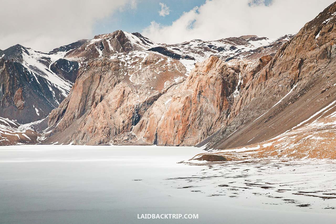
Finally, we made it to frozen Tilicho Lake, it was all white and still because of ice and snow, and a low cloud was hanging above it.
We could admire the lake from a viewing point, and we had the place just for ourselves. It was a well-deserved reward for our efforts that day.
This tranquil feeling lasted about ten or fifteen minutes, and after that, we started getting very cold, although we put the rest of our clothes on.
The strong wind was throwing snow in our faces and everywhere around, and there was nowhere to hide. We took a last look down at the lake and surrounding mountains and started to walk back.

The way down was easy after all, and we descended quite quickly back to our lodge, where we drank hot tea and tried to dry our boots for the rest of the evening.
We had a pretty basic Dhal Bhat for dinner and went to our freezing room to get some sleep for the next day.
As we've already mentioned, we did the Tilicho Lake trek at the beginning of April, but it was still frozen. Even though the lake must be wonderful without the ice cover, our photos will hopefully persuade you that this hike is worth it any time of the year.
In the end, we were super-excited that we have opted for this detour.
First of all, Annapurna Circuit is one of the most famous treks in Nepal, but the Tilicho Lake area is much less visited as it takes time and energy to get there, and thanks to it, the place keeps its peaceful, almost magical atmosphere.
Secondly, we are pretty sure that because we reached the line of 5000 meters, we were well acclimatized and crossed Thorong La Pass without greater difficulties in the next few days.

Travel Resources
Here you can find links to all the travel resources we use and which you might find helpful when planning your next holiday.
Accommodation: When looking for accommodation, we usually search hotels via Booking.com or Hostelworld.
Tours: Although we love to travel independently, some places are better to visit with a guided tour.
We prefer GetYourGuide for its easy-to-use interface and solid reputation. Another great alternative is Viator.
Rental Cars: When going on a road trip, we always use Rentalcars.com, a reliable site for booking a rental car in advance.
Flight Tickets: When looking for flight tickets, you can search Skyscanner to find the best price.
Travel Insurance: World Nomads and SafetyWing cover against risks of travel.


