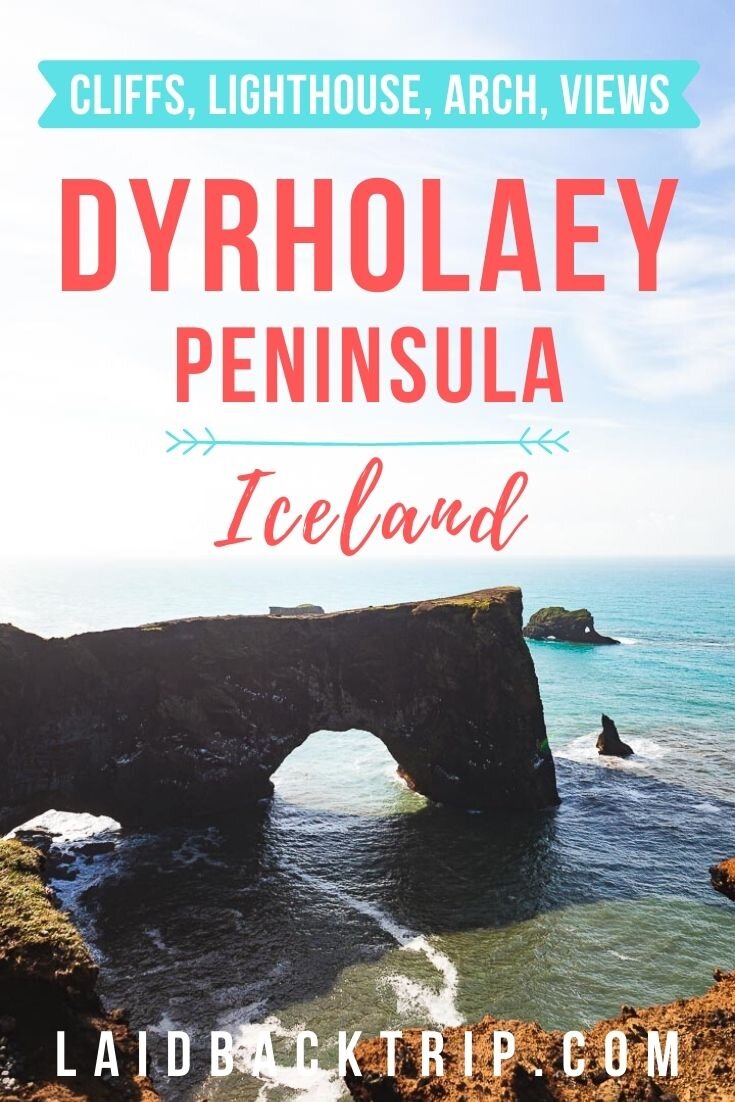
A Guide to Dyrhólaey Peninsula

With scenery like this, it's easy to see why we loved Dyrhólaey.
Dyrhólaey literally means Door Hill Island, so open that door, step through it, and join us in exploring one of Iceland's most stunning peninsulas.
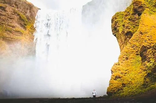
It's a gorgeous, sunny evening. It's the kind of evening we know we can't take for granted here on Iceland's South Coast. We're nearing Dyrhólaey, a 120‑meter‑high promontory and the southernmost point on mainland Iceland. The whole drive is incredibly scenic. And not just the Ring Road, but also the side road number 218, which we eventually join as it leads across the peninsula. It's getting late, but we take advantage of the midnight sun, a phenomenon during which it never gets dark at this time of year.
The views are incredible on both sides of the road, so we stop often and take photos almost behind every turn. We don't know where to look first, because the soft light makes everything feel even more magical. It's really quiet here, which adds so much to the atmosphere. And we can't wait to get out of the car and explore the Dyrhólaey Peninsula on foot.
But suddenly, there's a barrier across the road, and we can't go any farther. Dyrhólaey offers amazing views of the black sand beach, the unique stone arch, and the photogenic lighthouse, but as we learn from the sign on the barrier, it's also an important nesting site for migrating birds between May and June. They're not to be disturbed by curious visitors during this period. Because of that, the area is closed for a few more days between 7 PM and 9 AM (until the end of June) to protect the environment and let the birds nest.
Even though the information catches us off guard, because we've quickly gotten used to the idea that everything in Iceland is open 24/7, we change our plans on the spot and continue to Reynisfjara Beach instead. We turn around and save our visit to Dyrhólaey for the next day. We only hope the weather in the morning will be as gorgeous as it is now. Let's come back to this beautiful place tomorrow!
When we returned the next day, the weather held, and Dyrhólaey was just as beautiful as we expected.
Staying Near Dyrhólaey
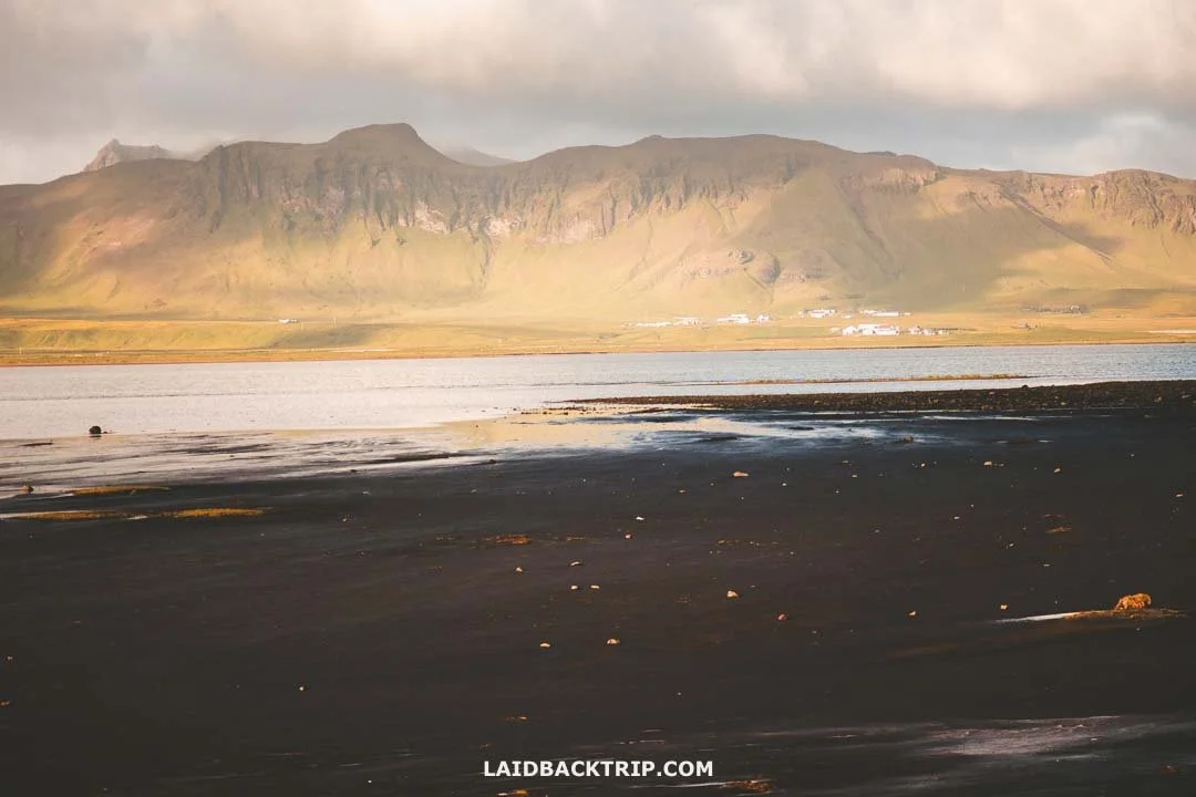
Before anything else, we went to see Reynisfjara and then had to find a place to spend the night. Since Dyrhólaey was just a 10‑minute drive from the small village of Vík í Mýrdal, which has a big campground and a few hotels, it wasn't too complicated. We got there around midnight and weren't sure how full the campground would be, but luckily, there were still spots left.
The campground was fine. It had a shared kitchen, and we got a good night's sleep there. The only small hiccup was the coin‑operated shower, as we didn't have any coins. While Iceland was as cash‑free as a country could be, this was the one exception that proved that nothing is ever 100%.
The village also has some nice hotels like the affordable hostel The Barn or the pricier but more comfortable Hotel Vík í Mýrdal. Since we camped the whole time in Iceland, we didn't worry about hotels, but I checked, and the village isn't the only place where you can stay near Dyrhólaey. Even closer to the peninsula are places like Hvammból Guesthouse or Hotel Dyrhólaey.
Getting to Dyrhólaey
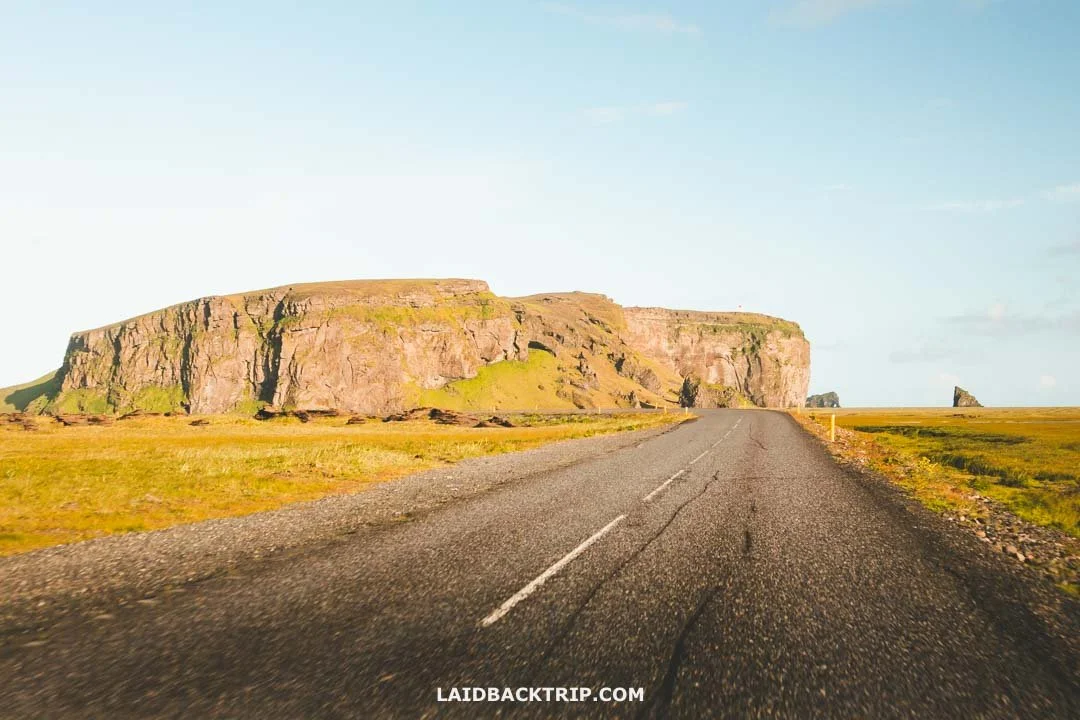
For us, getting to Dyrhólaey Peninsula, which sits just off the scenic Ring Road, was incredibly easy since we simply drove there by car. We woke up that day in Selfoss after driving the famous Golden Circle the day before, so we had roughly a 120‑kilometer journey ahead of us.
Because we were traveling the Ring Road counterclockwise, the turnoff to Dyrhólaey came about 12 kilometers before Vík í Mýrdal, the village where we eventually stayed for the night. Just before the turnoff, there was only a small yellow sign with the name of the peninsula, and if we hadn't had our GPS set, we could have easily missed it. Since we had to come back the next morning, we technically drove those 12 kilometers two more times before finally continuing toward Fjaðrárgljúfur.
We knew it would be another long day, so we started early. Our guess was right, and since the weather stayed good the whole day, it basically took us the entire day to travel between all these places. Had we driven straight through, we would have needed less than two hours to cover this stretch. But there was simply too much to see.
Even the drive to Dyrhólaey was incredibly scenic, and in the late evening, the road was completely empty.
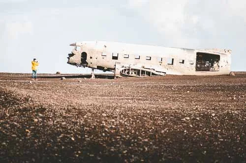
After spending the whole day on the road, exploring some of the most beautiful waterfalls in the country, like Seljalandsfoss, Skógafoss, and Kvernufoss, and after walking almost eight kilometers to (and back) the Sólheimasandur Plane Wreck, plus making tons of quick stops along the way, we finally reached the last stop on our itinerary, Dyrhólaey Peninsula.
Without a car, reaching Dyrhólaey would be difficult. The peninsula is off Route 1, and the public buses that travel this road don't stop here.
Normally, we'd suggest taking a tour instead. But in the case of Dyrhólaey, that's not so easy either. Most tour operators don't stop here either because they prefer more popular sites, like the waterfalls I mentioned above or Reynisfjara, the famous black sand beach. From Reynisfjara, you can actually see the cliffs, but only in the distance, since you won't have time to walk across the whole beach. A solution to this, although pricier, would be to book a private tour where you can choose the places you want to see.
Parking at Dyrhólaey
So as I said already, the next morning we had to drive back to Dyrhólaey from Vík í Mýrdal. After leaving the Ring Road, we turned onto road 218 (Dyrhólavegur). It wasn't very wide, but at least it was paved. There were two parking areas at Dyrhólaey, and we faced a choice right away.
We could either follow the paved road all the way to the main parking lot at the eastern point of the peninsula, which had a cafe, toilets, and access to the Reynisfjara viewpoint, or turn right onto the dirt road that would take us to the upper parking by the lighthouse. In the end, the choice didn't matter much because we walked between both places anyway.
On our way to the Reynisfjara viewpoint, we walked right past the lower parking.
But that morning, we decided to take the unpaved road that led to the lighthouse. The road sign suggested it was only for 4WD, but since the road looked fine, we tried it even in our 2WD. The drive was pretty steep, and if it had been rainy or icy, it wouldn't have been doable in the car we had. But on this sunny morning, with a bit of careful driving, it was perfectly fine (and honestly better than some of the side roads we encountered in the Westfjords later).
From what I checked recently, this whole section has been paved now, so the upper parking area is easily accessible for everyone. One more thing that changed since our visit, though not as positively, is that the once free parking at Dyrhólaey is now paid. The fee of 1000 ISK can be paid through the Parka app.
No Entry Fee to Dyrhólaey
When we were here, Dyrhólaey was still completely free to explore. And it still is, sort of. But if you arrive the same way we did, by car, you now have to pay for parking. So while Dyrhólaey technically remains ticket‑free, the parking fee basically makes it a paid attraction for most independent travelers. The same thing has happened not only here but also at places like Brúarfoss, Dynjandi, and Kirkjufell, so be prepared for these spots to add a little extra to your budget.

Paid parking or not, Dyrhólaey is still totally worth the stop.
Visiting Dyrhólaey on a Summer Morning
Dyrhólaey is an all‑year‑round destination, but as we learned the hard way, it's closed from the start of May until the end of June between 7 PM and 9 AM. As I said, on our first attempt, we arrived too late, and the peninsula was already closed. We often took advantage of visiting places in the evening, like Reykjadalur Hot Springs or Kolugljúfur Canyon, to avoid crowds, and that strategy worked perfectly there, but in the case of Dyrhólaey, it didn't. At least not during these two months.
When we arrived at Dyrhólaey the next morning, it was already after 9 AM, but the peninsula was still really quiet. There were no bus tours like the ones we saw at Geysir or Gullfoss earlier, and only a few independent travelers like us, so we could focus entirely on the beauty of Dyrhólaey without dealing with crowds. Early summer is also a good time for birdwatching here, but since we couldn't access the peninsula early or late in the day, a lot of the birds were out at sea.

Dyrhólaey was just gorgeous on that early summer morning.
We arrived right at the beginning of summer, and the weather couldn't have been more idyllic. It was a beautiful sunny day, and if it hadn't been for the relentless wind, we could almost say it was warm. But the wind made sure it wasn't, so we wore our usual layers, though this time we ditched the rain pants.
In the evening, we reached Skaftafell, and by then it had started to rain. And honestly, I have a feeling that Dyrhólaey on a cloudy, rainy day would be fascinating to explore, too. It would show its untamed side, but since there's practically nowhere to hide once you're out on the trail, I have to admit I was glad we stayed dry that morning. And I don't even want to imagine how windy it can get up there.
Things to See in Dyrhólaey
Dyrhólaey Peninsula was one of the most dramatic areas we visited along the southern section of the Ring Road. Since there was a lot to see and the scenery was incredible, it took us about three hours to explore all its highlights. When it rains, the whole place turns gloomy and mysterious, but because it was a sunny morning, we could enjoy amazing views in every direction. I have to admit we only had a vague sense of what waited for us at Dyrhólaey. We knew about the lighthouse, the massive sea arch, the cliffs, and the chance to see puffins. But the peninsula surprised us with far more than that. So, here's a list of Dyrhólaey's must‑sees in the order we visited them.
Hiking to Loftsalahellir Cave
We already mentioned that road 218 leading across Dyrhólaey was pretty scenic, but before we reached the headland, we made a stop at Loftsalahellir Cave. We had actually stopped there the evening before, since, unlike the headland, the cave was still accessible.
Because it was late, there was only one other campervan in the parking lot, but its occupants were nowhere to be seen, so we had the trail and the cave to ourselves. The trail was only about 200 meters long, but it went straight uphill, so it was a nice little workout before bed. The path was rugged, and if it had rained earlier, it would have been muddy and the whole walk much more challenging.
Once we reached the cave, we found out it was quite small. This natural opening in the tuff rock was formed by ancient explosive volcanic eruptions on the slopes of Geitafjall Mountain. We weren't sure if the stop would be worth it, since we couldn't find much information about it beforehand.
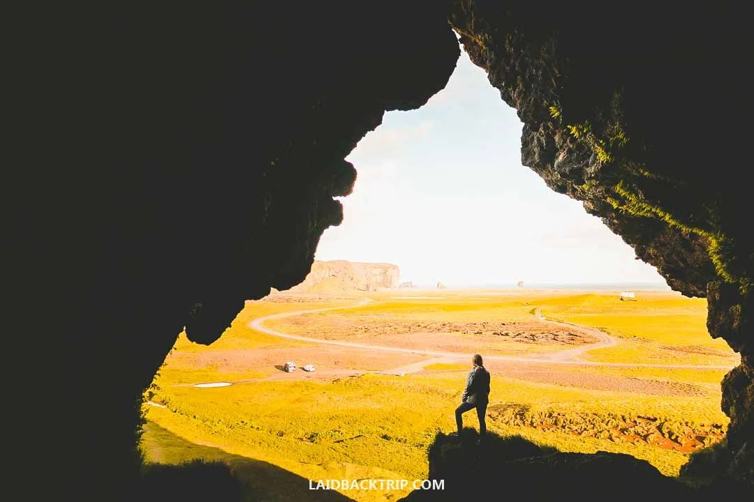
This view from Loftsalahellir Cave made that short uphill walk totally worth it.
But once we stepped inside and looked out across Dyrhólaey, we got our answer immediately. The views were incredible. With no one around and soft evening light, the whole scene in front of us looked almost painted. Not many people stop at Loftsalahellir Cave when visiting Dyrhólaey, and if the main area gets busy, we think this is a great little detour to get off the beaten path. Plus, the parking was free when we visited, as was the entrance to the cave.
Driving Along the Dyrhólaós Estuary
Another interesting place we saw on the peninsula that same evening was the Dyrhólaós Estuary, only a few hundred meters past the cave. We passed this large lagoon with brackish water on the way to the promontory, and what was really cool was that the road cut through its southwest tip, so we had water on both sides. The lagoon, fed by several glacial rivers and by seawater during high tide, is shallow and full of mudflats packed with crustaceans, worms, and larvae, making it a perfect feeding spot for birds like oystercatchers, plovers, redshanks, dunlins, sandpipers, and many others.
Dyrhólaós Estuary is great for birdwatching, but that evening we were mostly soaking in the views.
The info panel by Loftsalahellir Cave mentioned that this lagoon and the whole Dyrhólaey area are important habitats for more than 50 bird species, so besides the ones I already mentioned, you can also spot geese, ducks, terns, gulls, and more. When we were there, the lagoon was pretty quiet in terms of bird activity. But I have to admit I focused more on the scenery at that moment because the views were amazing.
Another interesting thing we learned is that the water of Dyrhólaós can sometimes be blocked by the beach's sand from Reynisfjara. When that happens, the water level rises by up to one meter before finally breaching the sand barrier and flowing into the sea again. We could see the lagoon mouth the next morning from one of Dyrhólaey's viewpoints, and the water was flowing without any problems.
Exploring the Dyrhólaey Lighthouse
The next morning, we headed to Dyrhólaey for the second time, and as I said, we chose to park at the upper parking area by the Dyrhólaey Lighthouse, called Dyrhólaeyjarviti in Icelandic. The lighthouse was only about two hundred meters from the parking lot, so it was a very short walk. The first lighthouse at Dyrhólaey was built in 1910, but the current white structure with the red lantern dates back to 1927.

Only maintenance crews were allowed to drive right up to the lighthouse, but from the upper parking we walked there in just a few minutes.
We saw some really nice lighthouses in Iceland, with a few of my favorites being in Reykjanes and Snaefellsnes Peninsula, but we were never able to go inside any of them, and this one was no exception. I remember visiting the Mizen Head Signal Station in Ireland and how cool that experience was, so it was a bit of a shame that it wasn't possible here. Still, even from the outside, the lighthouse was really photogenic.
Hiking the Dyrhólaey Trail
I already said that we had to walk a bit to reach the lighthouse, so now I want to talk more about the trail that took us along the top of Dyrhólaey. It was officially called the Dyrhólaey Hiking Trail, and at about 1.9 kilometers in length with roughly 100 meters of elevation gain (one way), it technically connected both parking areas. There was no loop, so we had to return the same way we came. Since we parked at the upper lot, we walked downhill first and uphill on the way back.
In terms of difficulty, I'd say it was one of the easier walks we did in Iceland, especially compared to hikes like Glymur Waterfall or Namafjall Hike, which were both longer and more demanding. The trail was roped off almost the entire time, sometimes only on the cliff side and sometimes on both sides, which made it incredibly easy to follow.
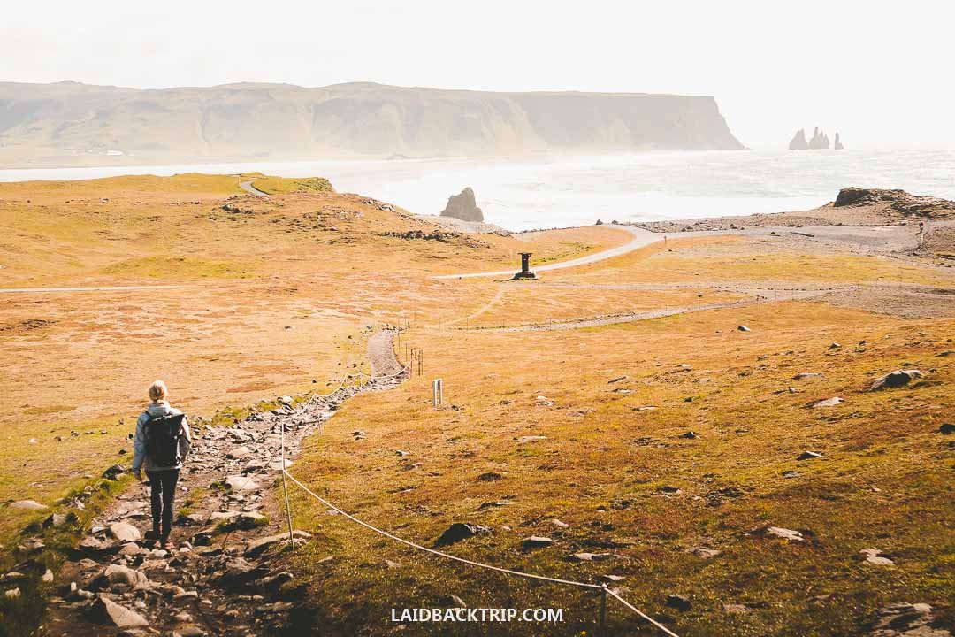
The morning we hiked at Dyrhólaey, the whole trail was really quiet.
There was nowhere to take a wrong turn or wander off. The trail was as straightforward as it gets. It followed the cliff's edge, offered several viewpoints, and never branched. Some sections were rugged, and if it had rained in the previous days, I'd say it would have been pretty muddy. Luckily, it wasn't.
When I say cliff's edge, the trail was obviously placed with safety in mind, so at times it kept a bit of distance from it. And for your own safety, stay on the designated path. There were signs warning that rockslides happen at Dyrhólaey from time to time, so staying away from the edge is safety rule number one here.
World Nomads provides travel insurance for travelers to cover their trip essentials, including sports and adventure activities.
SafetyWing is affordable travel insurance for backpackers, long-term travelers, and digital nomads.
Taking in the Views of Dyrhólaey Beach
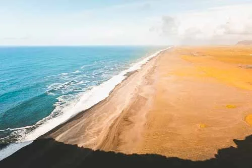
As soon as we left the parking lot and before we even reached the lighthouse, we came across the first viewpoint. It overlooked Dyrhólaey Beach, a black sand beach that stretched almost endlessly, pretty much as far as we could see with the fairly good visibility. The view from up here was simply breathtaking, and I really mean that.
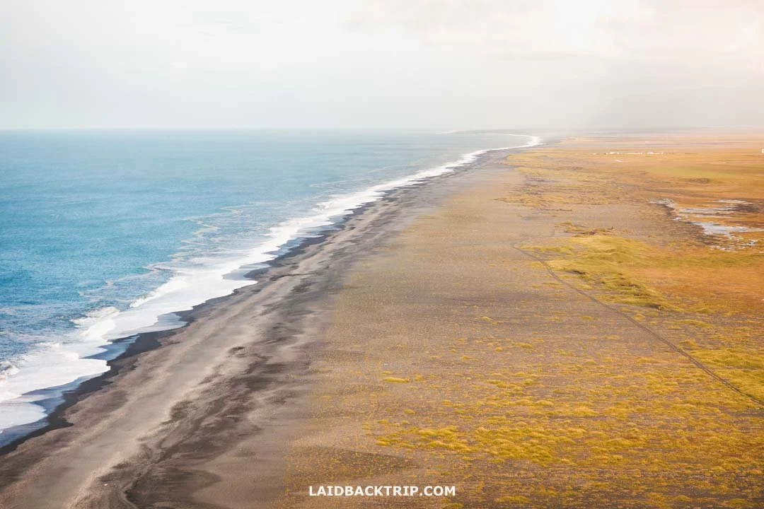
Even from the top of the cliffs, Dyrhólaey Beach looked like it had no end.
What made it even more interesting was that if we had walked along this beach for about 13 kilometers, we would have ended up at the Sólheimasandur Plane Wreck, which we had visited the day before. Since we were standing on a huge promontory about 120 meters above the sea, there was no way to get down to the beach from here. Not that we wanted to hike to the wreck again, but it would have been pretty cool to at least walk a short section of the sand.
As for access, we didn't find any turnoff from Road 218 that would take us down to the beach. This whole area is surrounded by farmland, with some of the properties also serving as accommodations. My guess is that the only real way to reach Dyrhólaey Beach directly is by staying at Mid Hvoll Cottages or Vestri Pétursey, both of which sit very close to the shoreline.
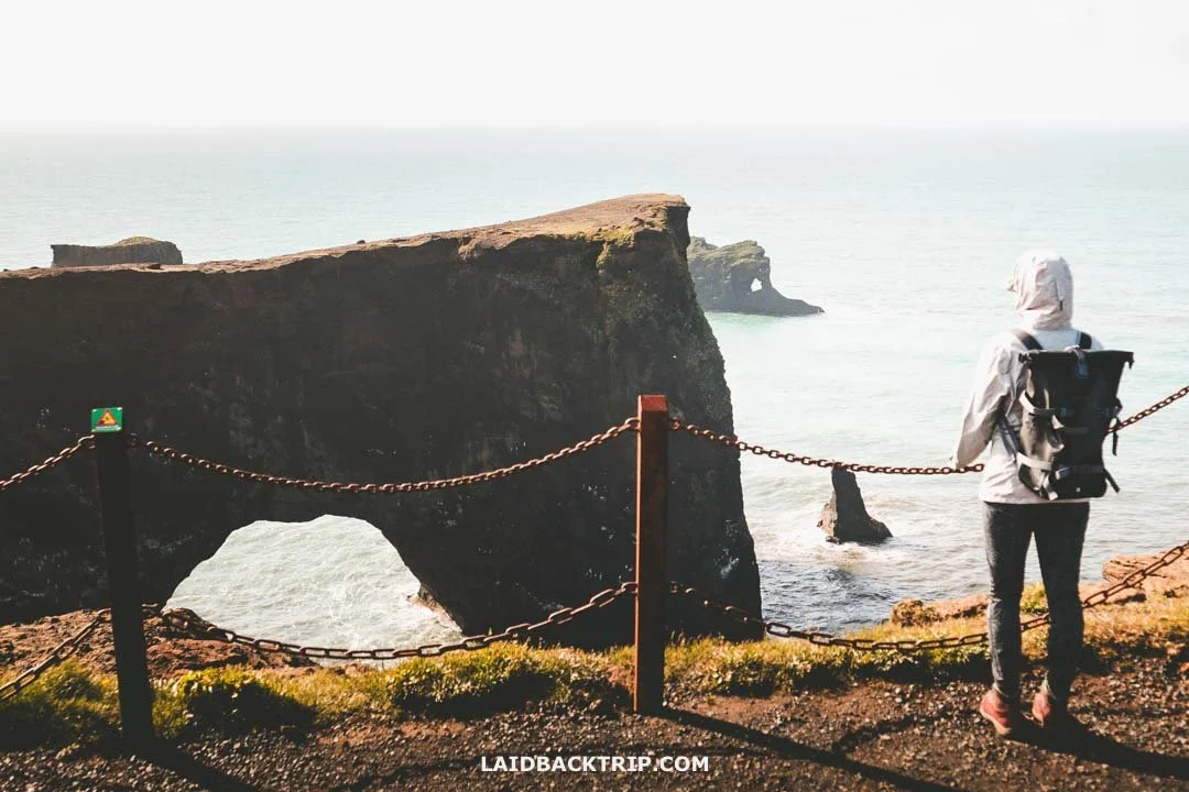
Marveling at the Dyrhólaey Arch
Only a short walk from here, past the lighthouse, we reached another Dyrhólaey highlight, the famous sea arch that is one of South Iceland's top attractions. It's a remarkable natural rock arch carved by centuries of Atlantic waves crashing into a volcanic headland, with a huge opening. It resembles a doorway through the cliffs, which is where the name comes from (the door hole), and it's supposedly large enough for small boats to pass through in calm conditions.
If there's one view that represents the whole of Dyrhólaey, it's definitely this massive rock arch. When I said a moment ago that the views of the black sand beach were breathtaking, this one had the same effect on us. It literally took our breath away. Even though the arch is still connected to the promontory, it's not accessible. And honestly, even if there had been a trail, I'm not sure I would have wanted to go out there. I was perfectly happy admiring it from a safe distance.

Dyrhólaey has the most famous sea arch in all of Iceland.
Seeing this huge sea arch jutting out into the ocean reminded me of something I mentioned earlier. Dyrhólaey is often described as the southernmost point of Iceland, but technically that title belongs to Kötlutangi, a vast sand spit east of the village of Vík. It was formed by sediment deposits after the 1918 eruption of the Katla volcano, but most people pass by without paying much attention to it, unless they're visiting the nearby Yoda Cave.
We're still talking about Iceland's mainland here, because the true southernmost point of Iceland is actually Surtsey. This uninhabited volcanic island lies off the southern coast and was created by a submarine eruption that broke the surface in 1963. Today it's a protected UNESCO World Heritage Site, like Þingvellir National Park or Vatnajökull National Park, and it's known as an untouched natural laboratory for studying how life colonizes new land. It's completely off-limits to the public.
As we stood on these 120‑meter‑high cliffs, watching the sea crash relentlessly into the rocks, we took a moment to appreciate how lucky we were to be here. The scenery was beyond words. And I don't mean only the endless ocean views and dramatic cliffs.
When we turned around and looked toward the mainland, Dyrhólaey was surrounded by coastal plains, wetlands, rivers, farmland, and mountains. And beyond all that, the ice‑capped Mýrdalsjökull glacier, which covers the active Katla volcano, was hiding in the clouds, waiting for its chance to reshape this landscape again. Thinking about how powerful this duo can be, we continued walking. This time, the trail led us downhill.
Spotting Puffins at Dyrhólaey
Dyrhólaey is mainly a nature reserve that protects the unique birdlife nesting across the whole peninsula. As I already said, we weren't able to enter the reserve on our first try because we arrived after hours, so we returned the next day.
We had read beforehand that we might be able to see puffins at Dyrhólaey, but we weren't sure. Even though we arrived at the end of June, which matches perfectly with their breeding season from roughly May to August, the issue was that by the time the reserve opened, most of the puffins nesting on the cliffs would already be out at sea hunting for fish.
So the chances didn't look too promising. But not long after we started walking the trail along Dyrhólaey's cliffside, we actually spotted a good amount of puffins. Unlike places such as Borgarfjörður or Látrabjarg, they were a bit farther from the trail. The whole experience felt more like proper birdwatching, since most of them were flying above the sea, but those other spots definitely gave us a better chance to see them up close in their burrows.

Dyrhólaey is a nesting area for puffins, but during the day we mostly saw them flying above the sea.
I had my telephoto lens with me, which I used not only for photos but also as a substitute for binoculars. Had we been able to visit Dyrhólaey in the late evening as we originally planned, which would have meant arriving in July or August, I'm pretty sure we would have seen a lot more of them.
Of course, it wasn't just puffins. The entire peninsula is home to many bird species. Between May and August, the same months as the puffins, you can spot fulmars, Arctic terns, guillemots, skuas, kittiwakes, eiders, and plenty of migratory birds. Since we're not birders, we definitely struggled to identify some of the birds flying above us. Luckily, there was an info panel showing a few of the species, which helped a little, but only slightly.
And maybe it was because we were there too late in the day, or maybe it's just the way the cliffs are shaped, but it felt like we saw fewer birds here than at other big colonies. There were plenty of birds, but most of them were far away, which reminded me a bit of the Cliffs of Moher, where birdwatching without binoculars is also pretty difficult.
Walking to Reynisfjara Beach Viewpoint
The evening before, once we learned that we wouldn't be able to see Dyrhólaey, we headed to Reynisfjara instead. Our plan was to catch a sunset there, and despite the midnight sun, it turned into a pretty amazing experience. The black sand beach was incredible, as were the basalt columns, the cave with its hanging basalt formations, the treacherous waves, and the sea stacks rising just offshore. And since it was already late in the day, we got to enjoy it without the crowds. It was simply one of the most beautiful evenings we spent in Iceland.
The interesting part was that Reynisfjara almost touches Dyrhólaey. And while it was possible to walk nearly to the point where the promontory rises from the sea, there was no direct access because of the cliffs and because this is where Dyrhólaós meets the ocean. We didn't mind, though, since we wouldn't have had the energy to explore Dyrhólaey even if it had been possible. But the next day, once we hiked down to Dyrhólaey's easternmost point, we got to enjoy a view of Reynisfjara one more time.
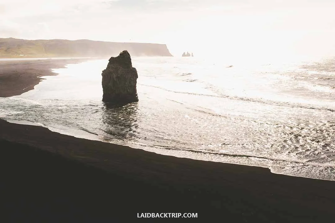
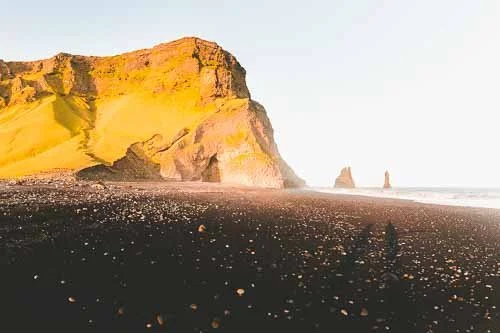
From Dyrhólaey we could see Reynisfjara's Arnardrangur sea stack dominating the beach's western end.
The view from up here was incredible. We could see not only the beach and the lagoon, but also Arnardrangur, a dramatic 14‑meter basalt stack rising from the black sand like an ominous tower. In the morning light, this stack, also called Eagle Rock because eagles supposedly nested there a couple of centuries ago, made the whole scene even more striking. It was our third day in Iceland, and by now we were getting used to the fact that no matter where we looked, everything appeared like a postcard. Just the next day, when we drove around the East Fjords, we saw more amazing black sand beaches and jagged basalt stacks.
We Spent About Three Hours at Dyrhólaey
All in all, we spent about three hours exploring the whole Dyrhólaey Peninsula. We spent around two hours hiking on the promontory in the morning (the walking part took about an hour, the rest was just soaking in the views), did that short hike to the cave the previous evening, made a few photo stops along the way, and with the driving between places, it really did add up to three hours, not counting the extra detour we made.
Without the cave, Lucie guessing the birds flying around with the help of that info panel, and honestly, us taking way too much time at the viewpoints, I'd say you could see Dyrhólaey in about two hours. Another thing that would have made us spend less time here would have been arriving in bad weather, like we did the next day at Jökulsárlón. The weather there was far from ideal, even though we stuck mostly to beaches and hot pools, and I really don't want to imagine how rough it would have been up here on top of the exposed cliffs.
Travel Resources
Here you can find links to all the travel resources we use and which you might find helpful when planning your next holiday.
Accommodation: When looking for accommodation, we usually search hotels via Booking.com or Hostelworld.
Tours: Although we love to travel independently, some places are better to visit with a guided tour.
We prefer GetYourGuide for its easy-to-use interface and solid reputation. Another great alternative is Viator.
Rental Cars: When going on a road trip, we always use Rentalcars.com, a reliable site for booking a rental car in advance.
Flight Tickets: When looking for flight tickets, you can search Skyscanner to find the best price.
Travel Insurance: World Nomads and SafetyWing cover against risks of travel.